-
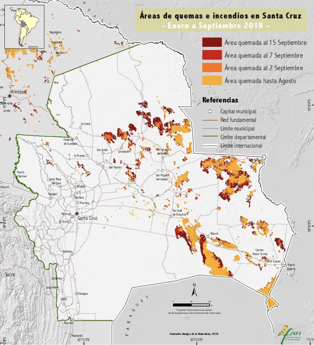
The latest data on the Bolivia fires is very bad news: 4.1 M hectares burned nationwide, 3.07M hectares in Santa Cruz; 1.48M hectares of forest burned, nearly all in Santa Cruz. incendios.fan-bo.org/Satrifo/reportes/IncendiosSCZ-FAN-15092019.pdf #BoliviaFires #SOSChiquitaníaOn twitter.com

 ♻️ 9 Retweets
❤️ 8 Favorites
Mood -3 🙁
♻️ 9 Retweets
❤️ 8 Favorites
Mood -3 🙁
-
The data, compiled by Fundación Amigos de la Naturaleza–Bolivia, is a rapid-response calculation based on satellite data. Because of cloud cover and changing conditions there are major error bars on these figures, but the trend is abysmal.Permalink On twitter.com
♻️ 1 Retweets
❤️ 1 Favorite
Mood -2 🙁
-
The fire-affected forested area is growing rapidly: up by 586 thousand hectares (+65%) from September 7 to September 15. Even acknowledging that this may include some adjustment to the prior figure, this is devastatingly fast.Permalink On twitter.com
♻️ 1 Retweets
❤️ 1 Favorite
Mood +1 🙂
-
The dark red is the area burned in the week ending September 15.Permalink On twitter.com
 Mood 0
-
The overall burned area in Santa Cruz department is about to pass the 2004 figure of 3.3M hectares, and surpassing the 2010 record of 3.8M hectares seems like only a matter of time.Permalink On twitter.com
♻️ 1 Retweets
❤️ 1 Favorite
Mood +3 🙂
-
The fires have consumed 381,567 hectares in Ñembi Guasu (32% of its total area), the first protected area created by an autonomous indigenous municipality. woborders.blog/2019/08/29/nembi-guasu-burns/Permalink On twitter.com
♻️ 3 Retweets
❤️ 2 Favorites
Mood +1 🙂
-
Charagua, the largely Guaraní municipality that contains Ñembi Guasu, has suffered the burning of 467,971 hectares overall.Permalink On twitter.com
♻️ 2 Retweets
❤️ 4 Favorites
Mood -2 🙁
-
29% of Otuquis National Park and one fifth of the San Matías Natural Area have burned, as has over 52% of the Ayoreo territory of Santa Teresita.Permalink On twitter.com
♻️ 2 Retweets
❤️ 4 Favorites
Mood +1 🙂